The National Parks and Mombasa Highway Travel Guide

This area covers the well-travelled route from Nairobi to Mombasa and a number of detours off it, along with the country’s most visited game parks: Maasai Mara, Amboseli, Meru, Chyulu Hills, Tsavo East and Tsavo West, and a trio of reserves in the north – Samburu, Buffalo Springs and Shaba. The Mombasa highwayis Kenya’s most important thoroughfare and overall is in good condition, although with a constant stream of heavy trucks it can be a hair-raising drive. With scenic interest marginal for much of the journey, the temptation is to head straight for the coast, stopping only at the Amboseli or Tsavo national parks. But there are some rewarding diversions off the highway, which are not greatly explored: east into Kambacountry and the pleasant towns of Machakos and Kitui, or southwest towards the base of Kilimanjaro and the Taita Hills.

Together with the coast, the game parks in this chapter are the most visited parts of Kenya, and the country’s archetypal image. This is not to take anything away from their appeal, for visiting any of them is an exceptional experience. In the 24,000 square kilometres covered by the nine parks, animals hold sway. Their seasonal cycles and movements, most spectacularly in the Maasai Mara’s wildebeest migration, are the dominant plots in the natural drama going on all around. Seeing the wildlife isn’t difficult, but it does require some patience and an element of luck that makes it exciting and addictive.

It’s likely that you will either already be booked on a safari, or you’ll book one once in Kenya, either from the coast or from Nairobi. Popular alternatives are to rent a vehicle, with or without a driver, or, if you’re alone or there are just two of you, and especially if you’re on a limited budget, to take a no-frills camping safari. There are details on the ins and outs of booking safaris in Basics, and plenty of operators listed in Nairobi and Mombasa.

Kitui

The small town of KITUI is a busy trading centre, its streets lined with arcaded shops, although it has no sights. Like Machakos, 100km to the west on the C97, it has sizeable populations of coastal Swahili and Somali people, descendants of the traders and travellers who criss-crossed Ukambani in the nineteenth century. The town’s mango trees were planted then, and are a reminder of the trading tradition.

Kitui was the home village of Kivoi, the most celebrated Kamba trader, who commanded a large following that included slaves. It was Kivoi who met the German missionary Ludwig Krapf in Mombasa, and who guided him to Kitui in 1849, from where he became the first European to set eyes on Mount Kenya.

Lake Chala

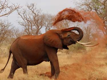
A four-square-kilometre crater lake north of Taveta, Lake Chala has one shore in Kenya and the other in Tanzania. Very deep and remarkably blue, it is a bewitchingly beautiful landscape, completely unsuspected from the plains below. Chala is still paddled over by a few friendly fishermen in their dugouts and is spiritually significant, with lake monster stories part of local folklore. From the 100m-high crater rim, it’s a steep descent to the lake and good walking shoes are advised. You might spot monitor lizards, baboons and vervet monkeys, and if lucky, a dik-dik or bushbuck. The bird list numbers more than 250 species, including peregrine falcons, which nest in Chala’s cliff-faces.

The lake, which is filled and drained by underground streams fed by the waters running off Kilimanjaro, is bilharzia-free. It was also once believed to be free of crocodiles. However, a crocodile killed a young British traveller swimming here in 2002, and you are very strongly advised not to enter the water. While locals swear the crocodile responsible was killed a few years later, there’s no reason to think the reptiles won’t colonize the lake again. They are resourceful survivors, and have been known to trek overland for long distances.

Machakos

The biggest town in Ukambani, the bustling, good-natured trading centre of MACHAKOS, is, after Nairobi, the main urban focus for the Kamba people. Imperial British East African Company’s first upcountry post, Machakos was established in 1889, and is therefore ten years older than Nairobi, 65km to the northwest; the capital was moved to Nairobi in 1899 as Machakos was bypassed by the Uganda Railway, then under construction.

Distinctly friendly, and overwhelmingly Kamba, Machakos has a backdrop of green hills and a tree-shaded, relaxed atmosphere to its old buildings that is quickly endearing. The weaving of sisal baskets (vyondo) is a visible industry and a major occupation for many women, either full-time, or behind the vegetable stand in the market. Machakos effervesces and it’s a great place to stay for a day or two, especially on Monday and Friday, market days. Look out for (though you can scarcely miss) the truly splendid and quite venerable mosque and the fine, upstanding Catholic cathedral, Our Lady of Lourdes. Despite its significance, you can walk round the compact centre of Machakos in twenty minutes.

The Kamba

The largely dry stretch of central Kenya from Nairobi to Tsavo and north as far as Embu has been the homeland of the Kamba people for at least five centuries. Also called the Akamba or Wakamba, they moved here from the regions to the south in a series of vague migrations, in search, according to legend, of the life-saving baobab tree, whose fruit can stave off the worst famines, and whose trunks hold large quantities of water.

With a diverse economy in better years, including mixed farming and herding as well as hunting and gathering, the Kamba slowly coalesced into a distinct tribe with one (Bantu) language. As they settled in the hilly parts, the population increased. But drier areas at lower altitudes couldn’t sustain the expansion, so trade for food with the Kikuyu peoples in the more fertile highlands region became a solution to the vagaries of their generally implacable environment.

In return for farm produce, the Kamba bartered their own manufactured goods: medicinal charms, extra-strong beer, honey, iron tools, arrowheads and a lethal and much-sought-after hunting poison. In the eighteenth and nineteenth centuries, as the Swahili on the coast strengthened their ties inland, ivory became the most important commodity in the trade network. With it, the Kamba obtained goods from overseas to exchange for food stocks with the highland tribes.

Long the intermediaries between coast and upcountry, the Kamba acted as guides to Swahili and Arab caravans, and led their own expeditions. Settling in small numbers in many parts of what is now Kenya, they were naturally enlisted by the early European arrivals in East Africa. Their broad cultural base and lack of provincialism made them confident travellers and employees, and willing porters and soldiers. Serving alongside British troops during World War I gave them insights into the ways of the Europeans who now ruled them. Together with the Luo and Kikuyu, they suffered tens of thousands of casualties in the white men’s wars. Even today, the Kenyan army has a disproportionately high Kamba contingent, while many others work in the police and as private security guards.

In the early years of colonialism, the Kamba were involved in occasional bloody incidents, but these were usually more the result of misunderstandings than any concerted rebellion. Although there was a major ruckus after an ignorant official at Machakos cut down a sacred ithembo tree to use as a flagpole, on the whole their trade networks and diplomatic skills helped to ease their relations with the British. As early as 1911, however, a Kamba movement rejecting European ways had emerged. Led by a widow named Siotune wa Kathake, it channelled opposition to colonialism into frenetic dancing, during which teenage girls became “possessed” by an anti-European spirit and preached radical messages of non-compliance with the government. Later, in the 1930s, the Ukamba Members Association (one of whose leaders was Muindi Mbingu) was formed in order to pre-empt efforts to settle Europeans in Ukambani and reduce Kamba cattle herds by compulsory purchase. Five thousand Kamba marched in peaceful protest to Kariokor market in Nairobi – a show of collective political will that succeeded in getting their cattle returned – and the settlers never came to Ukambani in any numbers.

Wamunyu, midway between Machakos and Kitui, was the birthplace of the modern Kamba woodcarving industry. Kamba men who served in World War I were introduced to the techniques of wood sculpture by the Makonde ebony carvers of the Tanganyikan coast. Today, the vast majority of woodcarvings in Kenya are still produced by Kamba artists, often in workshops far from Ukambani.

The Mombasa highway

The Mombasa highway (A109) is the main road linking Nairobi and Mombasa, and for the majority of its distance (482km) runs adjacent to the Nairobi–Mombasa rail line, a branch of the historic Uganda Railway. It’s regarded as the busiest (and most dangerous) road in the country thanks to the constant stream of trucks carrying goods along it from the port of Mombasa to be distributed in Nairobi and beyond.

The largest town on the highway is the sisal-processing centre of Voi, about two-thirds of the way to Mombasa. Before and after Voi are a string of smaller highway service towns, not much more than a scruffy line of petrol stations, dukas and roadside vendors, though they provide an opportunity for a break from the hectic drive. There are, however, several wildlife-related places where you might think about stopping over for a day or two, including the Kibwezi Forest and Ngutuni Game Sanctuary – as well as Tsavo East and Tsavo West national parks.

As you travel south down the highway, you may, in exceptionally clear conditions, see Kilimanjaro, either on the stretch between the small settlements of Sultan Hamud and Kiboko, or to the west of the Tsavo River. Your best chances are in the early morning or late afternoon.

Grogan’s Castle

Grogan’s Castle, a white and red mansion on an isolated hill rising from the plain, deserves a little detour on the way to Lake Jipe. This extraordinary residence was built during World War II by Ewart Grogan, one of the most influential early colonists. His mixed reputation was founded on a walk from the Cape to Cairo, which he undertook in 1898, on a notorious public flogging that he carried out on three of his servants (nearly killing one of them), and on his wealth: his status was such that he was able to dictate terms to the governor of Kenya before he even arrived in the colony, and at the peak of his prosperity his holdings extended to more than 2500 square kilometres.

The “castle”, which Grogan hoped would become a government agricultural training school (it never did), was run-down for decades, during which time it provided roosts for birds, bats and insects, but in 2010 the current owner, the high-profile former Taveta MP, Basil Criticos, opened it as a quirky hotel. It’s an enigmatic building, part hacienda, part folly, with huge arched windows. The enormous circular main lounge gives spectacular 360-degree views out towards Kilimanjaro to the north, the Pare Mountains to the southwest and Lake Jipe to the south. It’s a completely unique place, where you can share the sheer exuberance of Grogan’s vision – and even sleep in his room (Room 1) and use his claw-foot bath.

Oloitokitok

With Kilimanjaro towering in front of you, the C102 highway slices across the plains, curves through the pretty, spring-fed oasis of Kimana and then climbs up to the Maasai country town of OLOITOKITOK at an altitude of 1700m. You’ll pass through Oloitokitok (also known as Loitokikok) if heading direct to Taveta from Nairobi or planning to cross the border to Tanzania via the foothills of Kilimanjaro. It’s also a potential place from which to start a climb up the mountain.

Although it’s ignored by 99 percent of tourist traffic, this one-street hill town is in a stunning location, closer to Kilimanjaro than anywhere else in Kenya – Kibo Peak is just 25km from Oloitokitok as the crow flies. It’s a relaxed place to settle into if you’re interested in finding out more about the Maasai, as this is their easternmost major centre. Markets happen on Tuesdays and Saturdays. There’s a customs post on the north side of town (you’ll be waved through unless you’re going to Tanzania), but the actual border is 8km further south at Illasit, on the road to Taveta.

Samburu–Buffalo Springs National Reserves

Up in the north of the country, in the hot, arid lowlands beneath Mount Kenya, Samburu National Reserve was set up around the richest stretch of the Ewaso Nyiro (or Uaso Ngiro) River in the early 1960s. Although the river usually stops flowing for a month or two around January, the combination of near-permanent water and forest shade on the banks draws plentiful wildlife in the dry season and maintains many of the less migratory species all year round.

While the wildlife spectacle doesn’t always match that of the southern parks, the peace and scenic beauty of Samburu is unquestionable and, in the kind of mood swing which only an equatorial region can produce, the contrast with the fertile farming country of the Highlands just a few dozen kilometres to the south couldn’t be more striking. In the background, the sharp hill of Koitogor rises in the middle of Samburu Reserve, making a useful reference point. And on the horizon, 30km to the north, looms the gaunt red block of Ol Olokwe mountain. Buffalo Springs National Reserve, the continuation of Samburu on the south side of the river, and Shaba National Reserve, further downstream to the east, are often treated as if they were just part of “Samburu”. They remain distinct reserves with their own entrance fees, but will allow common game drives across them, which means you will only have to pay $70 once. That said, the Samburu–Buffalo Springs bridge crossing near the Samburu headquarters has been washed away more than once in recent years by flooding, though it’s presently operational. If the bridge is out of action, to get into the reserve from the opposite side, you have to go back to the highway and cross the bridge there, via Archer’s Post – a 45km diversion.

Adjoining Samburu are two community conservancies supported by the Northern Rangelands Trust. To the north is the 95-square-kilometre Kalama Community Wildlife Conservancy, of which a core 31 square kilometres is a crucial wildlife migration corridor, with just one, very high-end, boutique lodge, Saruni Samburu. To the northwest of the reserves lies the West Gate Community Conservancy, which covers an even larger district of semi-arid grazing land, but has a very small core conservancy area of less than 10 square kilometres around the exclusive Sasaab Lodge.

Shaba National Reserve

On the other side of the Isiolo–Archer’s Post A2 road from Samburu–Buffalo Springs road lies the Shaba National Reserve, where Joy Adamson experimented with the release of hand-reared leopards. Highly recommended, Shaba is much less visited and less developed than Samburu or Buffalo Springs and therefore feels more peaceful and solitary. If you’re driving, you’re likely to enter the reserve at Natorbe Gate (6km from the A2 highway junction a couple of kilometres south of Archer’s Post) on a road that rolls up and down through a lava field. The landscapes of Shaba are a lot more varied than you might expect, with the dramatic bulk of Bodich mountain rising behind the river to the north, and steep hills, culminating in Shaba peak, pressing in on the south.

For animals, Shaba is quite the equal of its two neighbours, with lots

of elephant, jackal, lion and plains game, including beautifully marked

Grevy’s zebra, reticulated giraffe and the gerenuk. Exploring in Shaba is very different from Samburu, where game drives tend to focus on the river; in

Shaba there are scattered natural springs around which the wildlife concentrates – ideal places to park up, switch off the engine and spend some time watching and waiting. Unlike Samburu and Buffalo Springs, where tracks are generally flat and well graded, those in Shaba are topped with gritty volcanic sand and a 4WD is usually required.

Taita Hills

Though largely unvisited, the Taita Hills region, accessed via the A23, has a fascinating and distinct culture. Despite the name, the hills don’t have any real connection with the Taita Hills Wildlife Sanctuary, which lies on the rolling plains to the south of the A23 road. From the junction at Mwatate, the C104 twists for 14km into precipitous and beautiful hills, striped with cliffs, waterfalls, intense cultivation and patches of thick forest, and rising to the (sometimes chilly) height of 2200m. The climate of the area is strongly affected by its proximity to the ocean, roughly about 100km away as the crow flies, and is so agreeable that during the 1950s the colonial administration briefly moved the district headquarters to Wundanyi from Voi to escape the harsh plains. Today there’s a high population density, reasonable prosperity and a strong sense of community up here. Most of the welcoming Taita people speak the Taita language, a member of the coastal Bantu family related to Swahili and Mijikenda.

Taita Hills Wildlife Sanctuary

One place attracting major tourist traffic in this district, particularly visitors on fleeting air safaris from the coast, is Taita Hills Wildlife Sanctuary, which isn’t in the Taita Hills at all, but in the hillocky lowlands west of Mwatate. Set up in 1973 by the Hilton hotel chain, the sanctuary is now owned and managed by Sarova Hotels, who successfully balance wildlife and human needs in an environment that, while not being fully natural, seems to work well for both.

For most of the year, the sanctuary is full of wildlife. There are more than fifty species of large mammals and three hundred species of birds here, and the sanctuary's small size means the rangers always have a good idea of where the key animals can be seen. It’s not uncommon to spot two dozen species in a morning game drive, among them lions, cheetahs, large herds of elephant and buffalo, and all the other southern plains grazers. During the drier times of the year, when the animals are not dispersed, the water sources beneath Salt Lick Lodge, on the southern side of the sanctuary, provide waterhole game-viewing, including a very good ground-level hide, far better than you could hope to experience at Treetops or The Ark.

The Thika-Garissa Road

The A3 is an important artery to the east and is in good condition for most of the way (323km) between Thika and Garissa, though expect lots of police roadblocks. It may look like an alternativeroute to the coast to the obvious, traffic-choked Mombasa highway on the map, but it would be very ill-advised to head this way under current circumstances. In the event that things improve for casual travellers, we’ve included here a couple of stop-offs with facilities for drivers.

A thriving trading centre 62km beyond Thika, MATUU is busiest at the top of the hill, near the easternmost of the town’s two communications masts, where you’ll find most shops and businesses, though its one good hotel (and petrol stations and bus passenger cafés) are all on the A3.

Another 67km on, MWINGI has a surprisingly attractive location in an area of rocky hillocks and woodland. Coming from the Thika direction, you first see the town more than 10km before you arrive, spread out across the boulder-dotted hills. Mwingi offers plenty of small places to eat and a decent hotel.

Tsavo West National Park

The combined area of Tsavo West and Tsavo East national parks makes this by far the biggest wildlife reserve in Kenya, and one of the largest in the world, sprawling across 20,812 square kilometres of dry bush country. It’s the same area as Wales, and two-and-a-half times bigger than Yellowstone National Park in the US.

Of the two Tsavos, Tsavo West, encircled by roads and encroaching human populations, is the most visited and the most developed. Yet within its vast 7000 square kilometre extent, the popular part that receives nearly all visitors is a “mere” 1000 square kilometres, known as the Developed Area, located between the Tsavo River and the Mombasa highway. Here, a combination of magnificent landscapes and good access and facilities (KilaguniSerena Safari Lodge and Severin Safari Camp both welcome casual visitors, and Kilaguni has fuel supplies) attracts visitors in large numbers, while the well-watered, volcanic soils support wooded grasslands and a great quantity and diversity of animal life – though it’s not always easily seen.

Game-viewing at the lodges

You may not be staying in the relative luxury of Kilaguni Serena Safari Lodge or Severin Safari Camp, but a visit to either can be highly rewarding, for the pleasure of sitting on the terrace with a cold beer, or having lunch (allow $25), while you watch the enthralling natural circus going on a few metres away. At acacia-shaded Severin, guests and wildlife are on exactly the same level, making the experience very intimate, while the waterholes at Kilaguni, spread beneath the panorama of the Chyulu Hills, are a well-known magnet for animal visitors.

At Kilaguni, dazzling birds hop everywhere, agama lizards skim along the walls (the miniature orange and blue dragons are the males in mating colours), hyraxes scamper between the tables, and dwarf mongooses are regular visitors. Out by the waterholes, scuffling baboon troops, several species of antelope and gazelle, buffalo, zebra, giraffe and elephant all provide a constant spectacle, with the possibility of the occasional kill adding tension. At dusk, bats swoop, while genets, jackals and hyenas lurk near the floodlights, drawn by the smell of dinner – though, thankfully, the lodge has stopped the practice of baiting them with meat scraps.

The camp at Severin, meanwhile, seems to be absorbed by its environment, and there’s nothing to stop the animals treating the whole place as their own. Signs warn visitors not to stray off the paths, but you’ll need little reminding, as families of warthogs trot past the terrace, impala and giraffe nibble audibly, and lion kills take place close to reception. Unlike Kilaguni, which is fenced, guests at Severin have to be escorted to and from their tents after dark.

Mzima Springs

The biggest attraction in Tsavo West is Mzima Springs. This stream of crystal-clear water is a delightful, and popular, spot, so you’re advised to arrive very early to avoid a possible tour-bus atmosphere. With luck, some of the night’s animal visitors may still be around, while the luxuriant growth around the water reverberates noisily with birds and monkeys.

You can walk around freely, as elephants and predators rarely visit, and there are KWS rangers posted by the car park to look after you, but make sure you’re not close to the water’s edge, where large crocodiles lurk. Equally be sure that you’re not between a hippo and the water, especially early or late in the day, or during wet weather. They seem settled in their routine, content to snort and flounder en masse, but are notoriously irritable animals.

There are two large pools, connected by a rush of rapids and shaded by stands of spectacular trees. These include date and raffia palms, water berries and figs, whose submerged roots absorb nutrients from the springs and whose fruit is a source of food for monkeys (vervet and Sykes’) and birds. At the side of the top pool, a circular underwater viewing chamber has been built at the end of a short pier. With luck (and it doesn’t happen on every visit), you’ll see the unforgettably comic tip-toeing of an underwater hippo, or the sinuous, streamlined stealth of a crocodile in motion, as well as the blue swirl of large fish.

Mzima Springs’ water is filtered to aquarium transparency by the lava of the Chyulu range, just to the north of here: the porous rock absorbs the water like a sponge and gravity squeezes it out into the springs. A direct pipeline from Mzima to Mombasa, completed in 1966, is the source of most of the city’s drinking water. Engineers devised a way of taking water from beneath the lava, but above the spring, preserving the area’s integrity. There are one or two signs of the pipeline, but most are unobtrusive.

You don’t have to be a botanist to enjoy Mzima’s two tree trails, with examples of various trees labelled with their common uses and their English, local and botanical names. It’s easy to spend a couple of hours in the area: try to sit for a while completely alone on the bank and you’ll begin to piece together the ecological miracle of the place, as the mammals, birds and other creatures forget about your presence.

Visiting the main parks

The first realization of where you are in Kenya’s big parks – among uncaptured, and for the most part unfenced, wild animals – can be truly arresting. It may take you a day or two to adjust, as your normal, human-centric view of the world is re-balanced towards an environment in which big creatures hunt, die, mate, feed and enjoy themselves all around you in a wilderness landscape not much changed in centuries. Which parks you choose to visit can seem at first like a pin-in-the-map decision: any of them can provide a store of amazing sight and sound impressions.

Amboseli, Tsavo West and Tsavo East, all in southern Kenya, three of the most accessible parks, with ever-busy game lodges, well-worn trails, large numbers of tourists and big herds of elephant. Amboseli, with its picture-postcard backdrop of Mount Kilimanjaro and guaranteed elephants, is an instant draw, but the flat landscape and lack of tree cover means you may be sharing the stunning vistas with dozens of very noticeable safari vehicles. Tsavo East, in contrast, is so huge you can usually escape company completely, although its sheer size makes the same easy for the animals, too. Tsavo West is also huge, but better watered, allowing higher concentrations of wildlife in a varied landscape that includes hills, woodland springs and lava flows. On the other hand, the bush and woodland landscape can make animal-viewing harder. The little-visited Chyulu Hills National Park, to the north and effectively an extension of Tsavo West, has smaller populations of animals because of its altitude, but those lucky enough to stay in one of the two luxury lodges on its perimeter will find exploring here on foot or horseback rewarding.

Maasai Mara has the most fabled reputation of Kenya’s parks, with horizons of wildlife on every side in a rich, rolling landscape of grasslands and wooded streams. Although it is somewhat isolated in the southwest, it is well worth the effort and cost of getting there, especially if you can arrange your visit during the yearly wildebeest migration. This takes place over an eight- to ten-week period, roughly between early July and early November, and is usually at its most spectacular at the end of August.

North of Mount Kenya, on the fringes of Kenya’s desert region, the adjoining national reserves of Samburu and Buffalo Springs, and, just to the east, Shaba National Reserve share the bounty of the Ewaso Nyiro River system. These reserves have a number of animal varieties not found in the southern parks, including northern races and species of giraffe, zebra, various antelope and ostrich. Each of the reserves is small, even compared with Amboseli, which lends an impression of great concentrations of animals and birds, especially in the dry season when water sources are magnets for the wildlife.

Over to the east of Mount Kenya, the Kenya Wildlife Service’s rescue and relaunch of Meru National Park, which in the 1990s had fallen into the hands of bandits and poachers, has been an impressive piece of work. Verdant Meru is one of the country’s most beautiful parks, and still relatively unvisited, despite having, among its few places to stay, some of the very best options in the country – at both the luxury and budget ends of the spectrum – and nowadays some of the best wildlife-viewing.

Planning your own trip? Prepare for your trip

Use Rough Guides' trusted partners for great rates

  • National Parks & Reserves
  • Kenya
Rough Guides Editors

written by
Rough Guides Editors

updated 26.04.2021

Ready to travel and discover
Kenya?

Get support from our local experts for
stress-free planning & worry-free travels

Plan my trip ⤍