Lake Naivasha
Naivasha, like so many Kenyan place names, is a corruption of a local Maasai name, this time meaning heaving or rough water, E-na-iposha, a pronunciation still used by Maa-speakers in the area. The grassy lakeshore was traditional Maasai grazing land for two centuries or more, prior to the lake’s “discovery” by Joseph Thomson in 1884. Before the nineteenth century was out, however, Thomson’s “glimmering many-isled expanse” had seen the arrival, with the railway, of the first European settlers. Soon after, the laibon Ole Gilisho, whom the British had appointed chief of the Naivasha Maasai, was persuaded to sign an agreement ceding his people’s grazing rights all around the lake – and the country houses and ranches went up. Today the Maasai are back, though very much as outsiders, either disputing grazing rights with the many European landowners still left here, working their herds around the boundary fences, or labouring on the vast horticultural farms around the lake.
The lake is slightly forbidding – but is hugely picturesque, with its purple mountain backdrop and floating islands of papyrus and water hyacinth. It is fresh water – Lake Baringo is the only other example in the Rift – and the water level has always been prone to mysterious fluctuations. At the beginning of the twentieth century, Naivasha completely dried up and the former lakebed was even farmed, until heavy rains a few years later caused it to return, swallowing up the newly established estates. Then again in 1945, the lake almost disappeared again from drought, but since the 1950s water levels have maintained a depth of at least half a metre, rising to 6m at times.
The fast lakeside road has brought tens of thousands of migrant workers to the farming estates, where they grow vegetables and flowers, mostly in giant, polythene greenhouses, for export by air to European supermarkets. Since the late 1980s, great stretches of acacia scrub have been cleared for the expansion of the farms, and ugly lines of squalid field-hand housing have sprouted in the dust between the plantations. The mixed, migrant community at impoverished at KARAGITA, now the largest lakeshore settlement.
But despite the development, and the ever-growing encroachment of farms and jobseekers, Lake Naivasha is still a place of considerable natural beauty. The lakeshore retains some patches of fairly unspoilt savanna and woodland, and boasts plenty of local wildlife. Even today, you can still see the odd giraffe as it lopes down to Crescent Island, or families of waterbuck or zebra munching on the lawns of the lakeside properties, and the area’s climate, with a light breeze always drifting through the acacias, along with the many hiking possibilities around the lake, makes it hard to beat as a first stop out of Nairobi.
On the northeastern side of the lake, NAIVASHA TOWN has little to offer as a place to stay, and unless you arrive late in the day, you may as well head straight down to the lake. If you plan to spend any time in the area, however, you may want to go into town to get fuel and cash and stock up on essentials first.
Lake Naivasha dangers
Beware, out on Lake Naivasha. The possibility that underground springs may feed the lake, its location on the floor of the Rift Valley, and its shallowness all combine to produce notoriously fast changes of mood and weather: grey and placid one minute, suddenly green and choppy with whitecaps the next. Boating mishaps are all too common and you should be sure your vessel has lifejackets and your “captain” and mate (don’t go out with only one crew) have radio contact with the shore, not just a dodgy cellphone connection. Watch out, too, for hippos, which can overturn a small boat easily if frightened or harassed. Although there’s no bilharzia in Naivasha, the hippos, the dense weeds, and the occasional sightings of crocodiles combine to offset any enthusiasm you might have had for a swim.
Mount Longonot
The prominent cone of the dormant volcano Mount Longonot (2777m) looms high above Lake Naivasha, flanked by thorny savanna slopes and visible for many kilometres around. It’s a relatively easy ascent, worth climbing for the fabulous views in every direction as you circle the rim.
The Rift Valley Music Festival
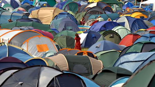
Taking its cue from Malawi’s increasingly popular Lake of Stars festival, the annual Rift Valley Music Festival is Kenya’s first international music festival, and has taken place every late August since 2010, at Fisherman’s Camp on the shores of Lake Naivasha. Energetic and dance-oriented on the Saturday, it turns more low-key and family-friendly on Sunday when the mood is blankets, picnics and beer. The highly recommended festival features mostly Kenyan artists and a few international acts playing from a single, central stage to an audience of a few thousand. There’s also a craft market, open-air cinema and children’s play area with face-painting, bouncy castle and the like. You can stay anywhere around the lake and walk, cycle or get a matatu every day, or book ahead if you want to stay on-site. Advance day tickets (excluding camping fee) cost Ksh2000 and weekend tickets Ksh4000)
The thorns of the rose
Despite the listing of Lake Naivasha as a Ramsar wetland site of global ecological importance in 1995, the future of the lake’s delicate ecosystem is far from secure. Naivasha’s multimillion-dollar horticultural industry is one cause for concern, particularly the use of pesticides on the lakeshore’s huge farms and the enormous volumes of water used to irrigate them.
It is becoming increasingly apparent, however, that the survival of the lake and its wildlife depends on a multitude of other factors ultimately linked to the country’s growing population. Since 1977 the number of people living near the lake has risen at least fivefold, and human waste has become a major problem due to inadequate sewage treatment facilities, with the result that some partially treated effluent is finding its way into the lake. The Malewa and Gilgil rivers (which flow into Lake Naivasha from the north) have also been dammed, rendering the lake even more vulnerable.
Consequently, the lake’s wildlife is seriously threatened. Until the exceptional 1997/98 rains raised the lake’s level, thereby diluting the pollutants, the fish eagle had been especially badly affected, though its numbers now appear to be stable. The birds were not getting enough to eat, and Louisiana crayfish, introduced in the 1970s for commercial fishing, were largely to blame. By eating their way through the lake’s flora (which, as well as acting as a soak for excess nutrients and a sediment trap, serves as food and cover for some species of fish and birds), the crayfish caused the water to become murkier, making hunting harder for the eagles. Fishermen also complain that tilapia and black bass have sharply declined due to agrochemicals washed into the lake, and many of the area’s 350 species of birds, as well as the hippos and other wildlife, are still in danger: the lily-trotter, the great crested grebe and the crested helmet shrike have already all but disappeared.
Some companies finally appear to be waking up to their responsibilities. Oserian, the huge Dutch-owned flower exporter, has developed a new way of fighting fungal diseases without resorting to chemicals, using geothermal steam to purge diseases in its greenhouses, while other companies have adopted computerized drip-irrigation to optimize their water efficiency.
Wildlife of Lake Naivasha
One of the lake’s most interesting features is its wildlife, especially its protected hippo population. Despite their bulk, hippos are remarkably sensitive creatures, with good night vision – always follow the advice at the lodges and campsites about where to venture after dark. You can also see giraffes, floating blithely through the trees, taking barbed wire and gates in their stride, and zebra, waterbuck, wildebeest and even the occasional eland are often spotted grazing in the farms and expansive grounds of the lodges and campsites that line Moi South Lake Road. Naivasha has extraordinary birdlife of all kinds, too, from grotesque, garbage-scavenging marabou storks to pet-shop lovebirds, doves cooing in the woods, weavers and warblers twittering in the acacia trees and splendid fish eagles, whose mournful cries fill the air like seagulls. On the water, the papyrus swamps are alive with kingfishers, herons and jacanas, while Lake Oloiden, once a bay of the main lake and now a separate saline lake, frequently attracts wayward flamingos.
Lake Nakuru National Park
Just 5km outside Nakuru, Lake Nakuru National Park is one of the most popular in the country and a must-see for wildlife enthusiasts, offering one of the best chances in Kenya of spotting black and white rhinos. With more than 300,000 visitors each year, this is one of the Kenya Wildlife Service’s two “premier parks” (the other being Amboseli). Though not large, it’s a beautiful park, the terra firma mostly under light acacia forest, well provided with tracks to a variety of hides and lookouts; the contrast between these animated woodlands and the soda lake with its primeval birds give it a very distinctive appeal. And while there is very good accommodation within the park boundaries, it’s also one of the easiest parks to visit for the day, with or without a vehicle. The easy-to-follow topography and signposted tracks mean you really can’t get lost and it’s a pleasure to drive around, which takes about three hours.
The park has undergone some quite remarkable changes in recent years due to the significant flooding that has affected all the Rift Valley lakes. Heavy seasonal rain swelled Nakuru by, it’s estimated, at least one-third in 2012, 2013 and 2014 (the 2015 long rainy season was a relatively light one in comparison). As a result, not only has the lake’s surface area and shape changed considerably, but the park’s infrastructure has been altered too (and probably permanently): KWS lost two campsites; the Main Gate had to be moved to higher ground (you’ll see the old gate buildings being lapped by the waves); and the marshy floodplain region at the southern end of the lake is now under deep water.
KWS has undertaken a major redesign of the park’s road layout and facilities as, unlike the other lakes like Ba-ringo and Naivasha, water levels are not expected to go down at Lake Nakuru anytime soon. There are several reasons for this. First, again unlike the other lakes, Nakuru has no outlet. Additionally, as well as the unprecedented heavy rains over the last few years, some underground springs have recently been discovered on the lake bed, suggesting that the lake is also fed from beneath the ground. Finally, it’s thought that recent initiatives to stop human encroachment on the Mau Forest Complex on the western edge of the Rift Valley, from which Nakuru receives much of its rainfall, have caused significantly more water to find its way down the escarpment to the lake.
So what does all this mean for the wildlife in Lake Nakuru National Park? Not a great deal in fact: while the animals have lost much of their grazing land, they are also thriving from the constant source of fresh water and flourishing habitat – though the lake no longer supports its formerly vast population of flamingos.
Around the park
Taken clockwise, the main park road runs east of the Main Gate via the lightly wooded acacia forest of the northeastern shores of the lake, past the Sarova Lion Hill Game Lodge and into an exotic-looking forest of candelabra euphorbia – great cactus-like trees up to 15m high. At the southern end of this zone you come into a stretch of more open country, past the turning (left) up to Lake Nakuru Lodge. From here there used to be a couple of side tracks leading down to the (now vanished) mudflats and the lakeshore but the road now turns southwest into the southern park’s dense acacia jungle. This is where you may see a leopard and – if they overcome their shyness – one of the park’s black rhino. Several kilometres further, the road opens again onto wider horizons with plenty of buffalo, waterbuck, impala and eland all around. You’re likely to see one of the park’s white rhino here, looking for good grazing, and this is also the most likely area for seeing the park’s herd of introduced Rothschild’s giraffe.
Lake Nakuru’s wildlife
Fortunately, in view of the flamingos’ here-today-gone-tomorrow caprice, there’s a lot more to the lake’s spectacle than the pink flocks it was once famous for. There’s a good number of mammals which are very easily seen and often come remarkably close to vehicles. Hippos have flourished in the less briny water, and by day can be seen snorting and splashing at various points around the lake. Nakuru has also become a popular venue for introduced species: there are Rothschild’s giraffe from the wild herd near Kitale, and lions and secretive leopards from wherever they’re causing a nuisance.
In the early 1990s, a number of black rhinos were relocated from Solio Game Ranch (see p.196), and ten white rhinos were donated by South Africa in 1994. These have bred exceptionally well, but despite the electric fencing around the entire perimeter of the park, Nakuru has not avoided the scourge of recent rhino poaching and it sadly lost five in 2014. Each rhino is now heavily guarded by armed KWS rangers and, as in other KWS parks, population numbers are no longer made available to the public. Nevertheless, as a visitor to the park, you have a very good chance of spotting one, and both KWS rangers and lodge staff will point you in the right direction.
Nakuru is Swahili for “place of the waterbuck”, and the park is indeed waterbuck heaven. With only a handful of lions and small numbers of leopards to check their population, the large, shaggy beasts number several thousand, and the herds (either bachelor groups or a buck and his harem) are large and exceptionally tame. Impala, too, are very numerous, though their lack of fear means you rarely witness the graceful flight of a herd vaulting through the bush.
The two other most often seen mammals are buffalo – which you’ll repeatedly mistake for rhinos until you get a look through binoculars – and warthog, scuttling nervously in singles and family parties everywhere you look. Elephants are absent, but you’re likely to see zebra, dik-dik, ostrich and jackal and, in the southern part of the park, eland and Thomson’s and Grant’s gazelle. More rarely you can encounter reedbuck down by the shore and bushbuck dashing briskly through the herbage. Along the eastern road, near Lake Nakuru Lodge, are several over-tame baboon troops to be wary of. The park is also renowned for its very large pythons – the patches of dense woodland in the southwest, between the lakeshore and the steep cliffs, are a favourite habitat.
Finally, though the reduced salinity may have put paid to flamingo numbers, the higher water levels have attracted other species of birds to Lake Nakuru in large numbers, including pelicans, fish eagles, herons, egrets, hammerkops and grebes.
Lake Nakuru's vanishing flamingos
Lake Nakuru was traditionally viewed as a flamingo lake par excellence. Several decades ago, up to two million lesser flamingos (maybe a third of the world’s population) could be seen here massing in the warm alkaline water to feed on the abundant blue-green algae cultivated by their own droppings. However, rising water levels in recent years – due to the significant flooding that has affected all the Rift Valley lakes – have caused a big drop in salinity, and the flamingos have simply flocked elsewhere. This has happened many times in the past (notably in the 1970s and again in the 1990s when the lake water was especially high) and today the majority of the gloriously pink, massed flocks are more easily seen at Lake Bogoria, with scattered communities also at Elmenteita, Magadi and Natron (in Tanzania).
Nairobi to Naivasha
Many travellers’ first proper view of the Rift Valley is from the souvenir-draped B3 Escarpment Road, originally built by Italian prisoners-of-war during World War II. This flirts with the precipice before dropping steeply down to the Rift through candelabra euphorbia and spikey agave. The little chapel at the bottom, also Italian-built, and often used as a picnic site, seems fitting in this Mediterranean scene. From here the B3 continues north to Mai Mahiu, where it turns westwards to Narok, while the C88 continues to Naivasha.
The alternative route, the more northerly A104 Uplands Road, crosses a broad, bleak plateau, where roadside traders sell rhubarb, plums, carrots and potatoes, and where, in the wet season, you can find yourself driving over a thick carpet of hailstones between gloomy conifer plantations. All this contrasts dramatically with the dusty plains of the Rift Valley. When you start descending, get out your binoculars and you can pick out herds of gazelle, Maasai with their cattle and, bizarrely, a satellite-tracking station.
On the escarpment section of both roads, souvenir stands sell crafts and small sheepskins (the latter often excellent value, though they’re not always very well cured, so don’t last long).
Nakuru
Kenya’s fourth-largest city (though it projects a noticeably busier and more energetic image than Kisumu, the third), NAKURU is a noisy, dusty and hustly place and a major transport hub for the Rift Valley. It’s also the closest jumping-off point for visits to the justly celebrated Lake Nakuru National Park and the vast Menengai crater (whose shamba- and conifer-cloaked southern flank you’ll have passed if approaching Nakuru along the A104 highway from Naivasha), as well as the departure point for trips to lakes Bogoria and Baringo, and the northern Rift Valley.
Modern Nakuru is still largely a workaday farmers’ town, with unadorned old seed shops and veterinary paraphernalia much in evidence on the main street, like a little Nairobi without the flashy veneer, its streets frequently undergoing ear-shattering repairs. The town can appear intimidating at first, and most visitors on their way to the national park stay in one of the lodges there. Still, Nakuru has some positive aspects: the market is animated and a pleasure to look around (though it, too, has its fair share of hassle), and there’s a glimmer of charm remaining in the colonnaded old streets and jacaranda-lined avenues at the edge of town.
BRIEF HISTORY
Nakuru came into existence on the thrust of the Uganda railway and owed its early growth, at least in part, to Hugh Cholmondeley, 3rd Baron Delamere (1870–1931). A wealthy landowner from Cheshire in the north of England, Lord Delamere was the territory’s first “white settler”, arriving in 1897 having walked over 1000km south from Berbera on Somalian coast. Delamere went on to dedicate his fortune to pioneering farming methods in the Rift Valley, advised and assisted by the Maasai (with whom he had a great rapport), and in 1903 he acquired four hundred square kilometres of land on the lower slopes of the Mau Escarpment. This was followed in 1906 by another two-hundred-square-kilometre block on the other side of the lake which he called Soysambu.
Eager to share the empty vistas with compatriots – though preferably with other Cheshire or Lancashire men – he promoted in England the mile-square plots being offered free by the Foreign Office. Eventually, some two hundred new settler families arrived and Nakuru – a name that as usual could mean various things, including “Place of the Waterbuck” (Swahili) and “Swirling Dust” or “Little Soda Lake” (Maasai) – became their country capital. It lies on the unprepossessing steppe between the lake and the flanks of Menengai crater. This desolate shelf has a nickname: “the place where the cows won’t eat grass”, the pasture’s iron deficiency explaining Delamere’s decision to move his herds down to Soysambu.